Al-Assad Airport, Latakia 04 SEPT 2015
September 24, 2015 - John LawrenceSatellite imagery of Latakia's Al-Assad Airport from September 4, 2015 reveals increased construction, possibly in preparation for Russian troops and equipment arrivals.
 |
 |
Satellite imagery of Latakia's Al-Assad Airport from September 4, 2015 reveals increased construction, possibly in preparation for Russian troops and equipment arrivals.
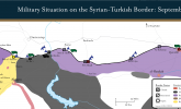
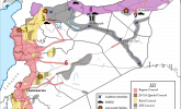
This map represents the military situation at the Syrian-Turkish border as of Sept. 11, 2015. Particular attention is paid to border crossings, many of which are now closed or highly restricted and under the control of a variety of groups including the Syrian regime, ISIS, Kurds, the Al-Qaeda affiliate Jabhat al-Nusra, and Syrian rebels.
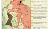
ISW has modified its Control of Terrain in Syria map to order to highlight the terrain which is assessed to be under the predominant control of Lebanese Hezbollah rather than the Syrian regime. Hezbollah seized the town of Qusayr southwest of Homs City in an offensive over April to June 2013 which marked its first overt intervention into the Syrian Civil War.
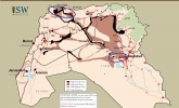
Is Bashar al-Assad losing the Syrian Civil War? Given recent reports of direct Russian military support for the Syrian regime as well as continued increases in the assistance provided by Iran and its proxies, this map details the known or assessed locations where Russia, Iran, and Iranian proxies have established headquarters or staging areas in support of the Syrian regime.
The Situation in Aleppo: June 24, 2015
Significant Syrian Offensives: June 6-July 9, 2015
The Jabhat al-Nusra and Rebel Campaign for Southern Syria: June 2014-June 2015
ISW has updated its ISIS Sanctuary map. This map, covering both Iraq and Syria, shows the extent of ISIS zones of control, attack, and support throughout both countries.
This map shows the movements of rebel forces in northern Syria during October and November 2012.