ISIS's Regional Campaign: May 2016
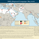
Jun 3, 2016 - Caitlin ForrestISIS continued to set conditions for Ramadan by launching attacks within and along the periphery of the Muslim world in order to foster regional disorder and push the boundaries of its caliphate contiguous to non-Muslim lands. The group is expanding its footprint to the edges of non-Muslim lands, as shown by arrests in Ingushetia, Russia and escalating attacks in majority-Muslim areas in Bangladesh and the Philippines and in Pakistan. ISIS is likely preparing to launch new affiliates in Bangladesh and the Philippines during the holy month of Ramadan, which begins on June 6.