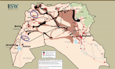
ISIS Sanctuary Map: September 15, 2015
September 15, 2015 - Institute for the Study of War
ISW’s updated ISIS sanctuary map includes a new attack zone in Deraa, southwestern Syria and an expanded sanctuary zone in Idlib, northwestern Syria. ISIS claimed an attack against the Syrian al-Qaeda affiliate Jabhat al-Nusra (JN) in Deraa on August 18, and also may be responsible for an ongoing assassination campaign against JN in Idlib.