 |
 |
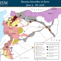
Russian Airstrikes in Syria Maps: September 2015- June 2016

ISW has produced nearly 60 maps on Russian airstrikes in Syria since they first began on September 30, 2015. The first map appeared less than 24 hours after the Russians began strikes and they continue today as do the strikes despite a declared "cessation of hostilities" and an alleged Russian withdrawal.
These maps quickly became the media's trusted source for the locations of Russian airstrikes and appeared around the world in major media outlets in print, broadcast, and online. These maps helped show the world that Russia's claims of striking "terrorists" were clearly not accurate as they repeatedly attacked mainstream opposition groups, particularly those working with the West. When intentionally false maps were produced by the Russian Ministry of Defense to show where they claimed strikes were occurring -- and that they were striking ISIS -- ISW's maps and analysis showed these claims to be untrue.
55 maps
10 months
Thousands of strikes
Hundreds of locations
All tracked by ISW and spearheaded by Genevieve Casagrande, Syria Analyst and the ISW Syria Team. See the entire Russian Airstrikes Map Collection.